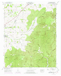
1948 Map of Beans Creek
USGS Topo · Published 1977About this map
Belvidere and the surrounding agricultural valley of Beans Creek define this landscape just after the mid-century. The Louisville and Nashville railroad cuts a diagonal path through the northwest, serving the small communities of Maxwell and Old Salem. The valley is dotted with family-named cemeteries such as Hatchett Cem, Needmore Cem, and Vanzandt Cem, providing a detailed record for genealogical study. To the east and south, the terrain rises sharply into the wooded ridges of Buncombe Ridge and Flat Top. These uplands are marked by numerous hollows like Gugelman Hollow and distinctive formations such as the Punch Bowl. The presence of Hickory Mill Spring and Rock Spring suggests the importance of natural water sources to the local economy and early settlement patterns before modern infrastructure reached the more remote corners of the county.
Find a feature on this map
76 named features on this map. Tap any name to fly to it.
Don’t see what you’re looking for? This feature index may not catch every label — zoom into the map to look around manually.
Map Details
Editions of this 1948 Beans Creek Map
2 editions found
Other maps of this area

1888 · Scottsboro
USGS Topo · 1:125,000

1892 · Scottsboro
USGS Topo · 1:125,000

1928 · Decherd
USGS Topo · 1:62,500

1936 · King Cove
USGS Topo · 1:24,000

1936 · Beans Creek
USGS Topo · 1:24,000

1936 · Hytop
USGS Topo · 1:24,000

1936 · Winchester
USGS Topo · 1:24,000

1936 · Huntland
USGS Topo · 1:24,000

1936 · Belvidere
USGS Topo · 1:24,000

1936 · Pitcher Ridge
USGS Topo · 1:24,000