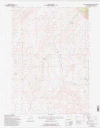
1993 Map of Bear Creek Ranch
USGS Topo · Published 1997About this map
Bear Creek Ranch serves as a primary point of reference in this landscape on the eastern edge of the Bighorn National Forest. The map documents a rugged drainage system where Bear Creek and Salt Creek carve through the high terrain of Big Horn County. Local water management is evident at the Lampman Reservoirs, while the Bear Creek Ranch Road provides the principal access through the valley floor. Survey markers and notable high points such as Black Butte, Eagle Rock, and the geodetic marker VABM 5612 Lost define the verticality of the area. This 1990s revision, based on earlier aerial photography, captures the network of light-duty and unimproved roads that trace the complex topography between the Eleventh Auxiliary Meridian and the national forest boundary.
Find a feature on this map
14 named features on this map. Tap any name to fly to it.
Don’t see what you’re looking for? This feature index may not catch every label — zoom into the map to look around manually.
Map Details
Editions of this 1993 Bear Creek Ranch Map
This is the sole edition of this map. No revisions or reprints were ever made.
Other maps of this area

1898 · Bald Mountain
USGS Topo · 1:125,000

1901 · Bald Mountain
USGS Topo · 1:125,000

1955 · Cody
USGS Topo · 1:250,000

1955 · Sheridan
USGS Topo · 1:250,000

1958 · Cody
USGS Topo · 1:250,000

1958 · Sheridan
USGS Topo · 1:250,000

1960 · Medicine Wheel
USGS Topo · 1:24,000

1960 · Devils Kitchen
USGS Topo · 1:24,000

1960 · Shell
USGS Topo · 1:24,000

1960 · Bear Creek Ranch
USGS Topo · 1:24,000