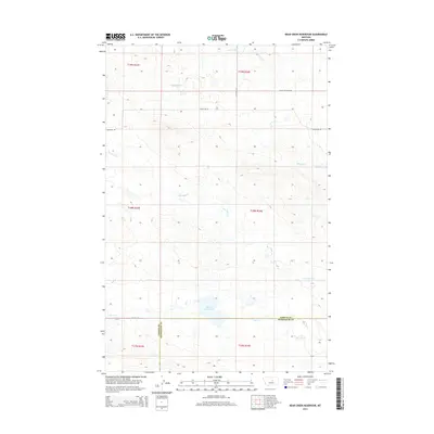
2014 Map of Bear Creek Reservoir
USGS Topo · Published 2014About this map
Bear Cr Reservoir serves as a central landmark in this high-plains landscape where the border between Fergus and Petroleum counties divides the drainage. The area is defined by its seasonal watercourses, with Bear Cr and Box Elder Cr winding through the terrain alongside other local drainages like Antelope Cr and Blood Cr. This 2014 survey documents a modern rural network of section lines and gravel roads, including Valentine Rd and Tullock Ln, which provide access to this ranching country. The transition from the more established county routes to specialized tracks like Kasier Resevoir Rd and Antelope Ln illustrates the sparse, working nature of the Central Montana prairie at the start of the twenty-first century.
Find a feature on this map
16 named features on this map. Tap any name to fly to it.
Don’t see what you’re looking for? This feature index may not catch every label — zoom into the map to look around manually.
Map Details
Editions of this 2014 Bear Creek Reservoir Map
This is the sole edition of this map. No revisions or reprints were ever made.
Other maps of this area

1954 · Lewistown
USGS Topo · 1:250,000

1959 · Lewistown
USGS Topo · 1:250,000

1985 · Griffee Coulee
USGS Topo · 1:24,000

1985 · Bear Creek Reservoir SE
USGS Topo · 1:24,000

1985 · Sloan Reservoir
USGS Topo · 1:24,000
1985 · Kachia Reservoir
USGS Topo · 1:24,000
1985 · Bear Creek Reservoir
USGS Topo · 1:24,000
1985 · Bohemian Corners
USGS Topo · 1:24,000

1986 · Wild Horse Lake
USGS Topo · 1:24,000

1986 · Teigen NW
USGS Topo · 1:24,000