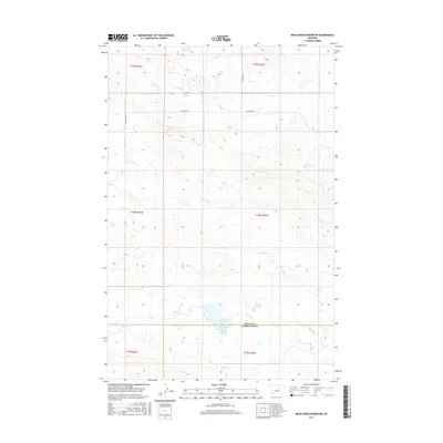
2017 Map of Bear Creek Reservoir
USGS Topo · Published 2017About this map
Bear Cr Reservoir and Lincoln Reservoir define the water management of this high plains landscape at the border of Fergus and Petroleum counties. The map documents a sparsely populated ranching region where drainage is dictated by a series of intermittent and permanent waterways, including Box Elder Cr, Blood Cr, and Antelope Cr. The presence of Valentine Rd provides one of the few primary access points through the surveyed townships, which are marked by the grid of the Public Land Survey System. This terrain illustrates the transition between higher drainage basins and the lower coulees, showing how the local topography has been harnessed for water storage through the construction of reservoirs in an otherwise arid environment.
Find a feature on this map
14 named features on this map. Tap any name to fly to it.
Don’t see what you’re looking for? This feature index may not catch every label — zoom into the map to look around manually.
Map Details
Editions of this 2017 Bear Creek Reservoir Map
This is the sole edition of this map. No revisions or reprints were ever made.
Other maps of this area

1954 · Lewistown
USGS Topo · 1:250,000

1959 · Lewistown
USGS Topo · 1:250,000

1985 · Griffee Coulee
USGS Topo · 1:24,000

1985 · Bear Creek Reservoir SE
USGS Topo · 1:24,000

1985 · Sloan Reservoir
USGS Topo · 1:24,000
1985 · Kachia Reservoir
USGS Topo · 1:24,000
1985 · Bear Creek Reservoir
USGS Topo · 1:24,000
1985 · Bohemian Corners
USGS Topo · 1:24,000

1986 · Wild Horse Lake
USGS Topo · 1:24,000

1986 · Teigen NW
USGS Topo · 1:24,000