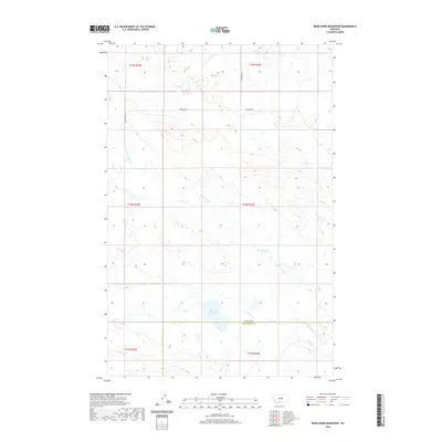
2020 Map of Bear Creek Reservoir
USGS Topo · Published 2020About this map
Bear Creek Reservoir sits at the southern edge of this landscape, marking the transition between the rolling drainages of central Montana. The terrain is defined by a network of seasonal watercourses, including Blood Cr in the east and the winding path of Box Elder Cr, which cuts diagonally across the central sections. This map documents the boundary between Fergus and Petroleum counties as it existed in the early 21st century. The sparse infrastructure, limited primarily to Valentine Rd and Antelope Ln, reflects the open ranching and agricultural character of this region. Local history and genealogy researchers can use the detailed township and range divisions to pinpoint specific family landholdings near Antelope Cr or the various forks of Bear Cr that feed into the reservoir.
Find a feature on this map
14 named features on this map. Tap any name to fly to it.
Don’t see what you’re looking for? This feature index may not catch every label — zoom into the map to look around manually.
Map Details
Editions of this 2020 Bear Creek Reservoir Map
This is the sole edition of this map. No revisions or reprints were ever made.
Other maps of this area

1954 · Lewistown
USGS Topo · 1:250,000

1959 · Lewistown
USGS Topo · 1:250,000

1985 · Griffee Coulee
USGS Topo · 1:24,000

1985 · Bear Creek Reservoir SE
USGS Topo · 1:24,000

1985 · Sloan Reservoir
USGS Topo · 1:24,000
1985 · Kachia Reservoir
USGS Topo · 1:24,000
1985 · Bear Creek Reservoir
USGS Topo · 1:24,000
1985 · Bohemian Corners
USGS Topo · 1:24,000

1986 · Wild Horse Lake
USGS Topo · 1:24,000

1986 · Teigen NW
USGS Topo · 1:24,000