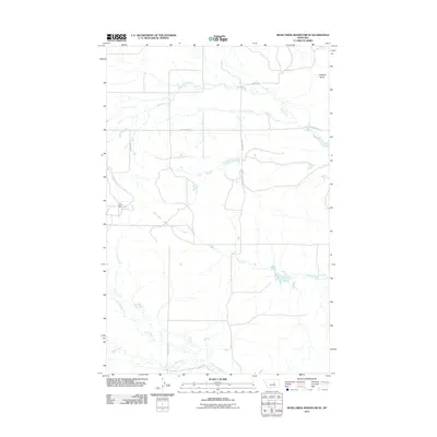
2011 Map of Bear Creek Reservoir SE
USGS Topo · Published 2011About this map
Blood Creek and Sage Creek weave through this section of Fergus County, defining a landscape of sprawling ranchland and drainage basins. The area is characterized by a network of rural roads such as Valentine Rd and Southworth Ln, which connect isolated homesteads and ranch properties across the northern plains of Montana. In the northeast corner, Haystack Butte rises as a prominent topographical landmark, while the water management of the region is evident at the Lund Dam on Sage Creek. These watercourses, including Box Elder Creek and Bear Creek, suggest the importance of seasonal flow and irrigation for the agricultural operations that have long sustained this part of the state.
Find a feature on this map
10 named features on this map. Tap any name to fly to it.
Don’t see what you’re looking for? This feature index may not catch every label — zoom into the map to look around manually.
Map Details
Editions of this 2011 Bear Creek Reservoir SE Map
This is the sole edition of this map. No revisions or reprints were ever made.
Other maps of this area

1954 · Lewistown
USGS Topo · 1:250,000

1959 · Lewistown
USGS Topo · 1:250,000

1985 · Bear Creek Reservoir SE
USGS Topo · 1:24,000

1985 · Valentine
USGS Topo · 1:24,000

1985 · Sloan Reservoir
USGS Topo · 1:24,000
1985 · Kachia Reservoir
USGS Topo · 1:24,000
1985 · Pipes Coulee
USGS Topo · 1:24,000
1985 · Bear Creek Reservoir
USGS Topo · 1:24,000

1986 · Wild Horse Lake
USGS Topo · 1:24,000

1986 · Dry Blood Creek West
USGS Topo · 1:24,000