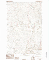
1985 Map of Pipes Coulee
USGS Topo · Published 1985About this map
The Sacagawea River winds through this central Montana landscape, defining a terrain shaped by deep drainage systems and high plateaus. This 1985 provisional survey of Fergus County captures a remote region where water is the primary architect of the geography, evidenced by the many branching coulees that feed into the river system. Notable watercourses include Pipes Coulee, Hay Coulee, and Schoneke Coulee, which cut through the dry hills. A historical point of transit, Cottonwood Crossing, appears along the river's path, marking a rare fixed point of reference in an area otherwise dominated by the natural features of Antelope Creek and Crooked Creek. This map is particularly valuable for understanding the hydrology of the plains and identifying traditional crossings used before modern infrastructure altered local travel patterns.
Find a feature on this map
9 named features on this map. Tap any name to fly to it.
Don’t see what you’re looking for? This feature index may not catch every label — zoom into the map to look around manually.
Map Details
Editions of this 1985 Pipes Coulee Map
This is the sole edition of this map. No revisions or reprints were ever made.
Other maps of this area

1943 · Landusky
USGS Topo · 1:125,000

1954 · Carter Coulee
USGS Topo · 1:24,000

1954 · Lewistown
USGS Topo · 1:250,000

1959 · Lewistown
USGS Topo · 1:250,000

1971 · Kepple Bottoms
USGS Topo · 1:24,000

1971 · Hanson Flat
USGS Topo · 1:24,000

1984 · Zortman
USGS Topo · 1:100,000

1985 · Brown Spring
USGS Topo · 1:24,000
1985 · Dovetail Butte
USGS Topo · 1:24,000

1985 · Bear Creek Reservoir SE
USGS Topo · 1:24,000