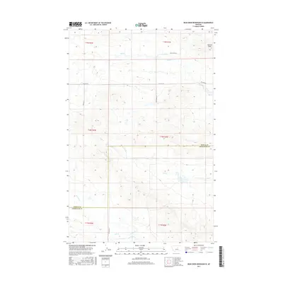
2017 Map of Bear Creek Reservoir SE
USGS Topo · Published 2017About this map
Haystack Butte rises in the northeast corner of this high-plains landscape, serving as a primary navigational landmark in the rugged territory where Fergus and Petroleum counties meet. This 2017 topographic record documents a vast ranching and rangeland environment defined by its drainage systems. Watercourses like Blood Cr and Sage Cr carve through the terrain, indicating the vital role of seasonal hydrology in this part of central Montana. A sparse network of local thoroughfares, including Valentine Rd and Blakeslee Rd, provides the only structural framework for the few inhabitants of these vast townships. The map illustrates how public land surveys have organized the area into townships and ranges, such as t18n r25e, preserving a traditional western land-use pattern where the geography of Box Elder Cr and Bear Cr dictates the placement of roads and property boundaries.
Find a feature on this map
16 named features on this map. Tap any name to fly to it.
Don’t see what you’re looking for? This feature index may not catch every label — zoom into the map to look around manually.
Map Details
Editions of this 2017 Bear Creek Reservoir SE Map
This is the sole edition of this map. No revisions or reprints were ever made.
Other maps of this area

1954 · Lewistown
USGS Topo · 1:250,000

1959 · Lewistown
USGS Topo · 1:250,000

1985 · Bear Creek Reservoir SE
USGS Topo · 1:24,000

1985 · Valentine
USGS Topo · 1:24,000

1985 · Sloan Reservoir
USGS Topo · 1:24,000
1985 · Kachia Reservoir
USGS Topo · 1:24,000
1985 · Pipes Coulee
USGS Topo · 1:24,000
1985 · Bear Creek Reservoir
USGS Topo · 1:24,000

1986 · Wild Horse Lake
USGS Topo · 1:24,000

1986 · Dry Blood Creek West
USGS Topo · 1:24,000