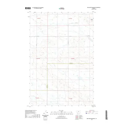
2020 Map of Bear Creek Reservoir SE
USGS Topo · Published 2020About this map
Haystack Butte rises as a prominent landmark in the northeast corner of this central Montana landscape, where the high plains transition between Fergus and Petroleum Counties. This terrain is defined by a network of drainage systems that carve through the open country, including Blood Cr in the north and the winding course of Sage Cr through the center. In the southern portion of the quadrangle, Box Elder Cr and Bear Cr flow through the township sections, tracing the natural contours of the ranching frontier. Human presence is marked by long, straight utility roads such as Valentine Rd and Southworth Ln, which follow the rigid grid of the Public Land Survey System. The map illustrates the characteristic isolation of this region, where life is organized around the intersection of sparse county roads and these perennial or intermittent watercourses.
Find a feature on this map
15 named features on this map. Tap any name to fly to it.
Don’t see what you’re looking for? This feature index may not catch every label — zoom into the map to look around manually.
Map Details
Editions of this 2020 Bear Creek Reservoir SE Map
This is the sole edition of this map. No revisions or reprints were ever made.
Other maps of this area

1954 · Lewistown
USGS Topo · 1:250,000

1959 · Lewistown
USGS Topo · 1:250,000

1985 · Bear Creek Reservoir SE
USGS Topo · 1:24,000

1985 · Valentine
USGS Topo · 1:24,000

1985 · Sloan Reservoir
USGS Topo · 1:24,000
1985 · Kachia Reservoir
USGS Topo · 1:24,000
1985 · Pipes Coulee
USGS Topo · 1:24,000
1985 · Bear Creek Reservoir
USGS Topo · 1:24,000

1986 · Wild Horse Lake
USGS Topo · 1:24,000

1986 · Dry Blood Creek West
USGS Topo · 1:24,000