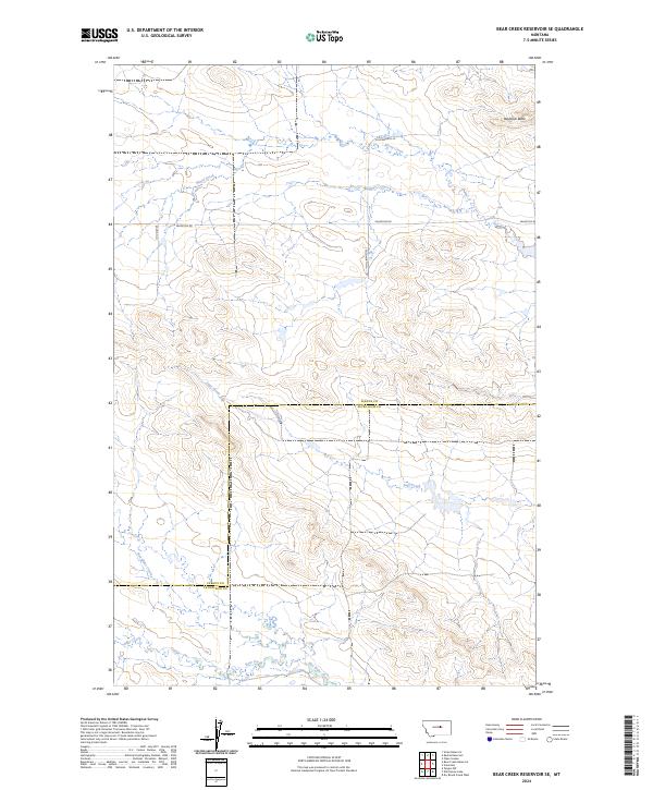
2024 Map of Bear Creek Reservoir SE
USGS Topo · Published 2024About this map
Haystack Butte rises over a landscape defined by an intricate network of intermittent waterways along the border of Fergus and Petroleum counties. The drainage patterns of Blood Creek in the north and Sage Creek through the center illustrate the erosional character of the Montana plains. These prairie drainages, along with Bear Creek and Box Elder Creek further south, dictate the placement of local thoroughfares like Valentine Rd and Southworth Ln. This survey documents a contemporary view of the region's ranching infrastructure and section lines, where the vastness of the terrain is punctuated by small reservoirs and family-named routes such as Bauman Ln. The map effectively shows how early 20th-century land divisions under the Public Land Survey System continue to shape modern land use in this part of Montana.
Find a feature on this map
15 named features on this map. Tap any name to fly to it.
Don’t see what you’re looking for? This feature index may not catch every label — zoom into the map to look around manually.
Map Details
Editions of this 2024 Bear Creek Reservoir SE Map
This is the sole edition of this map. No revisions or reprints were ever made.
Other maps of this area

1954 · Lewistown
USGS Topo · 1:250,000

1959 · Lewistown
USGS Topo · 1:250,000

1985 · Bear Creek Reservoir SE
USGS Topo · 1:24,000

1985 · Valentine
USGS Topo · 1:24,000

1985 · Sloan Reservoir
USGS Topo · 1:24,000
1985 · Kachia Reservoir
USGS Topo · 1:24,000
1985 · Pipes Coulee
USGS Topo · 1:24,000
1985 · Bear Creek Reservoir
USGS Topo · 1:24,000

1986 · Wild Horse Lake
USGS Topo · 1:24,000

1986 · Dry Blood Creek West
USGS Topo · 1:24,000