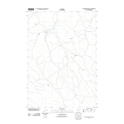
2011 Map of Bear Creek School
USGS Topo · Published 2011About this map
Bear Creek and its many tributaries, including Vance Creek and Billup Creek, carve a complex drainage system through the high plains of Powder River County. This landscape is defined by its distinct topographical landmarks, from the prominent Nipple Butte and Chico Buttes in the north to Red Butte in the south. The distribution of family-named features like Mac Alister Draw and Jojo Draw reflects the ranching heritage of this Montana interior. Grounded in the early 21st century, the map shows a sparse network of county roads such as Quietus Rd and Passage Rd, which provide the primary access to these isolated drainages. For genealogists, the Dufford Cemetery remains a key historical anchor in an area otherwise characterized by vast open range and intermittent watercourses like Finn Creek and Cedar Creek.
Find a feature on this map
20 named features on this map. Tap any name to fly to it.
Don’t see what you’re looking for? This feature index may not catch every label — zoom into the map to look around manually.
Map Details
Editions of this 2011 Bear Creek School Map
This is the sole edition of this map. No revisions or reprints were ever made.
Other maps of this area

1954 · Hardin
USGS Topo · 1:250,000

1955 · Sheridan
USGS Topo · 1:250,000

1957 · Hardin
USGS Topo · 1:250,000

1958 · Hardin
USGS Topo · 1:250,000

1958 · Sheridan
USGS Topo · 1:250,000

1962 · Sheridan
USGS Topo · 1:250,000

1971 · Cabin Creek NW
USGS Topo · 1:24,000
1971 · Cabin Creek NE
USGS Topo · 1:24,000
1971 · Box Elder Draw
USGS Topo · 1:24,000
1972 · Reanus Cone
USGS Topo · 1:24,000