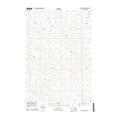
2014 Map of Bear Creek School
USGS Topo · Published 2014About this map
Bear Creek School and the Dufford Cem serve as the primary historic landmarks in this rural corner of Powder River County. The landscape is defined by a complex network of drainages and prominent geological elevations, including the Chico Buttes and Nipple Butte. Water sources are critical features of this terrain, with named springs such as 08S45E24CADD01 Spring and 08S46E30CCCB01 Spring providing vital points of interest alongside Bear Cr and Vance Cr. Transportation in the area relies on a system of remote corridors like Sayle Rd and Quitus Rd, which navigate the various draws including Mac Alister Draw and Jojo Draw. The map provides a detailed view of the cadastral divisions across T8S and T9S, showing how early settlement patterns were influenced by the rugged topography of the Red Butte vicinity.
Find a feature on this map
31 named features on this map. Tap any name to fly to it.
Don’t see what you’re looking for? This feature index may not catch every label — zoom into the map to look around manually.
Map Details
Editions of this 2014 Bear Creek School Map
This is the sole edition of this map. No revisions or reprints were ever made.
Other maps of this area

1954 · Hardin
USGS Topo · 1:250,000

1955 · Sheridan
USGS Topo · 1:250,000

1957 · Hardin
USGS Topo · 1:250,000

1958 · Hardin
USGS Topo · 1:250,000

1958 · Sheridan
USGS Topo · 1:250,000

1962 · Sheridan
USGS Topo · 1:250,000

1971 · Cabin Creek NW
USGS Topo · 1:24,000
1971 · Cabin Creek NE
USGS Topo · 1:24,000
1971 · Box Elder Draw
USGS Topo · 1:24,000
1972 · Reanus Cone
USGS Topo · 1:24,000