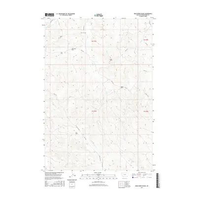
2017 Map of Bear Creek School
USGS Topo · Published 2017About this map
The Dufford Cem and Bear Creek School anchor this rural landscape in Powder River County, Montana, providing key landmarks for genealogical and local history research. The terrain is defined by prominent topographical features such as Chico Buttes, Nipple Butte, and Red Butte, which rise above the surrounding drainages. A network of local watercourses, including Mud Springs Cr, Finn Cr, and Vance Cr, dictates the movement through the region, often paralleled by the established road system of Quietus Rd and Bear Creek Rd. Several named geographic depressions, such as Mac Alister Draw and Jojo Draw, further illustrate the complex erosion patterns and family names tied to the land. This survey reflects a contemporary look at a remote ranching and agricultural region where traditional place names and land use patterns persist.
Find a feature on this map
30 named features on this map. Tap any name to fly to it.
Don’t see what you’re looking for? This feature index may not catch every label — zoom into the map to look around manually.
Map Details
Editions of this 2017 Bear Creek School Map
This is the sole edition of this map. No revisions or reprints were ever made.
Other maps of this area

1954 · Hardin
USGS Topo · 1:250,000

1955 · Sheridan
USGS Topo · 1:250,000

1957 · Hardin
USGS Topo · 1:250,000

1958 · Hardin
USGS Topo · 1:250,000

1958 · Sheridan
USGS Topo · 1:250,000

1962 · Sheridan
USGS Topo · 1:250,000

1971 · Cabin Creek NW
USGS Topo · 1:24,000
1971 · Cabin Creek NE
USGS Topo · 1:24,000
1971 · Box Elder Draw
USGS Topo · 1:24,000
1972 · Reanus Cone
USGS Topo · 1:24,000