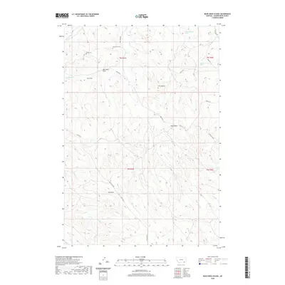
2020 Map of Bear Creek School
USGS Topo · Published 2020About this map
Bear Creek School and the Dufford Cem represent the community core of this remote drainage system in Powder River County. The landscape is defined by a series of prominent rises including Chico Buttes, Nipple Butte, and Red Butte, which overlook the complex network of draws and creeks that feed into the larger regional basins. Local nomenclature is deeply tied to the ranching geography, visible in features like Mac Alister Draw, Jojo Draw, and the numerous named springs such as 08S45E24CADD01 Spring. A web of unpaved transit routes, including Quietus Rd and Otter Creek Rd, connects these isolated homesteads and landmarks across the rugged terrain, tracing the natural contours of Vance Cr and Bales Cr.
Find a feature on this map
32 named features on this map. Tap any name to fly to it.
Don’t see what you’re looking for? This feature index may not catch every label — zoom into the map to look around manually.
Map Details
Editions of this 2020 Bear Creek School Map
This is the sole edition of this map. No revisions or reprints were ever made.
Other maps of this area

1954 · Hardin
USGS Topo · 1:250,000

1955 · Sheridan
USGS Topo · 1:250,000

1957 · Hardin
USGS Topo · 1:250,000

1958 · Hardin
USGS Topo · 1:250,000

1958 · Sheridan
USGS Topo · 1:250,000

1962 · Sheridan
USGS Topo · 1:250,000

1971 · Cabin Creek NW
USGS Topo · 1:24,000
1971 · Cabin Creek NE
USGS Topo · 1:24,000
1971 · Box Elder Draw
USGS Topo · 1:24,000
1972 · Reanus Cone
USGS Topo · 1:24,000