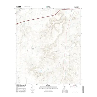
2016 Map of Bear Mountain
USGS Topo · Published 2016About this map
Bear Mtn rises above the drainage basins of the Palo Pinto Creek system in this 2016 study of Eastland County. The landscape is defined by the branching tributaries of W Fork Palo Pinto Cr and S Fork Palo Pinto Cr, which carve through the terrain near Cook Canyon. Several small reservoirs, including Dickey Lake, Crawford Lake, and Fambro Lake, dot the region, supporting local ranching and agricultural operations. Genealogy researchers will find the Cook Cem positioned centrally among these hills, while modern infrastructure is represented by the Cook Canyon Ranch Airport and the corridor of Frontage I-20 at the northern edge. The map captures a transitional landscape where traditional ranching elements, such as family-named landmarks and cemeteries, coexist with contemporary transportation networks.
Find a feature on this map
19 named features on this map. Tap any name to fly to it.
Don’t see what you’re looking for? This feature index may not catch every label — zoom into the map to look around manually.
Map Details
Editions of this 2016 Bear Mountain Map
This is the sole edition of this map. No revisions or reprints were ever made.
Other maps of this area

1890 · Stephenville
USGS Topo · 1:125,000

1890 · Breckenridge
USGS Topo · 1:125,000

1891 · Palo Pinto
USGS Topo · 1:125,000

1894 · Eastland
USGS Topo · 1:125,000

1918 · Palo Pinto
USGS Topo · 1:125,000

1920 · Stephenville
USGS Topo · 1:125,000

1954 · Abilene
USGS Topo · 1:250,000

1958 · Abilene
USGS Topo · 1:250,000

1959 · Gordon
USGS Topo · 1:62,500

1965 · Huckabay SW
USGS Topo · 1:24,000