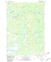
1982 Map of Bear Point
USGS Topo · Published 1983About this map
The Menominee River serves as the winding natural boundary between Michigan and Wisconsin in the early 1980s, creating a landscape of riverine islands and sharp bends like The Oxbow. This survey captures the borderlands between Menominee and Marinette counties, dominated by the timber and recreation lands of the Escanaba River State Forest. The terrain transitions from the high ground of Bear Mountain to the extensive marshlands and water bodies of the south, including Lake Noquebay and its surrounding Lake Noquebay State Public Hunting Grounds. Small settlements and landmarks like Sturgeon Landing and the Middle Inlet Lookout Tower anchor a network of local forest roads and rural routes, while numerous gravel pits reflect the area's local resource extraction. Water access is a primary feature, with public landings at Bear Point County Park and several smaller lakes such as Lake Mary.
Find a feature on this map
43 named features on this map. Tap any name to fly to it.
Don’t see what you’re looking for? This feature index may not catch every label — zoom into the map to look around manually.
Map Details
Editions of this 1982 Bear Point Map
This is the sole edition of this map. No revisions or reprints were ever made.
Other maps of this area

1939 · Marinette
USGS Topo · 1:48,000

1939 · Porterfield
USGS Topo · 1:48,000

1942 · Porterfield
USGS Topo · 1:48,000

1942 · Wausaukee
USGS Topo · 1:48,000

1947 · Wausaukee
USGS Topo · 1:48,000

1949 · Stephenson
USGS Topo · 1:48,000

1954 · Escanaba
USGS Topo · 1:250,000

1957 · Escanaba
USGS Topo · 1:250,000

1958 · Escanaba
USGS Topo · 1:250,000

1963 · Porterfield
USGS Topo · 1:62,500