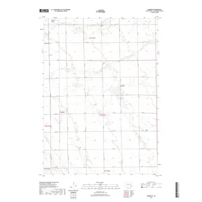
2017 Map of Beardsley
USGS Topo · Published 2017About this map
Beardsley sits at the center of this Hutchinson County landscape, reflecting the grid-iron organization of South Dakota's agricultural heartland. The area is defined by its small-town cemeteries and isolated markers, such as the Christina Hensel Koth Gravesite and Dakota City Cem, which offer significant value for genealogists tracing early families in the region. The map reveals the hydrology of the plains, where branches of the prairie creeks like Dawson Cr and S Br Lonetree Cr cut through the sections. This 2017 survey details the intersection of modern infrastructure and heritage, including the Parkston Municipal Airport in the northwest corner. Numerous family-associated burying grounds, such as Pietz Cem and Rosenfeld Cem, are spaced throughout the townships, indicating the distribution of 19th and 20th-century rural communities that once thrived between these section lines.
Find a feature on this map
36 named features on this map. Tap any name to fly to it.
Don’t see what you’re looking for? This feature index may not catch every label — zoom into the map to look around manually.
Map Details
Editions of this 2017 Beardsley Map
This is the sole edition of this map. No revisions or reprints were ever made.
Other maps of this area

1898 · Olivet
USGS Topo · 1:125,000

1955 · Sioux Falls
USGS Topo · 1:250,000

1955 · Mitchell
USGS Topo · 1:250,000

1957 · Milltown
USGS Topo · 1:24,000

1958 · Sioux Falls
USGS Topo · 1:250,000

1959 · Mitchell
USGS Topo · 1:250,000

1977 · Oak Hollow
USGS Topo · 1:24,000

1978 · Oak Hollow
USGS Topo · 1:24,000
1978 · Kaylor
USGS Topo · 1:24,000
1978 · Tripp
USGS Topo · 1:24,000