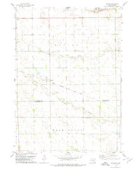
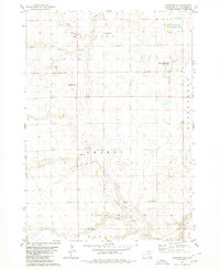
1978 Map of Kaylor
USGS Topo · Published 1979About this map
Kaylor serves as the primary hub of this eastern South Dakota landscape, situated at the junction of Dawson Creek and the Chicago Milwaukee St Paul and Pacific railroad line. The settlement pattern reflects the agricultural development of the late 1970s, with a grid of rural roads connecting isolated farmsteads across the townships of Kaylor and Washington. Local genealogy is well-documented through several dedicated burial grounds, including Dennewitz Cem, Siamental Cem, and St Johns Cem. The drainage of the land is defined by the winding paths of Dawson Creek and Lonetree Cr, which intersect the rolling terrain. Near the northern boundary, Gravel Pits indicate localized mineral extraction supporting the area's infrastructure and road network at the time of this survey.
Find a feature on this map
12 named features on this map. Tap any name to fly to it.
Don’t see what you’re looking for? This feature index may not catch every label — zoom into the map to look around manually.
Map Details
Editions of this 1978 Kaylor Map
This is the sole edition of this map. No revisions or reprints were ever made.
Other maps of this area

1898 · Olivet
USGS Topo · 1:125,000

1955 · Sioux Falls
USGS Topo · 1:250,000

1957 · Tschetter Colony
USGS Topo · 1:24,000

1957 · Scotland
USGS Topo · 1:24,000

1958 · Sioux Falls
USGS Topo · 1:250,000

1978 · Tripp SE
USGS Topo · 1:24,000
1978 · Kloucek Lake
USGS Topo · 1:24,000
1978 · Haucks Lake
USGS Topo · 1:24,000
1978 · Tripp
USGS Topo · 1:24,000
1980 · Parkston SE
USGS Topo · 1:24,000