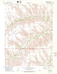
1978 Map of Beardsley
USGS Topo · Published 1979About this map
Beardsley and Blakeman serve as the primary hubs in this western Kansas landscape, where the agricultural and transport infrastructure of Rawlins County is clearly defined. The Burlington Northern railroad corridor parallels the drainage of North Beaver Creek, a critical lifeline for the local economy. The terrain is deeply incised by multiple branches of Beaver Creek, creating a complex series of draws and ridges across the townships of Celia, Logan, Beaver, and Burntwood. Local industry is represented by several extraction sites including a Gravel Pit and a Sandpit, while the Blakeman Cem provides a fixed point of reference for genealogists tracing family roots in this rural community. The map demonstrates how the railroad and watercourses dictated the placement of these early prairie settlements.
Find a feature on this map
14 named features on this map. Tap any name to fly to it.
Don’t see what you’re looking for? This feature index may not catch every label — zoom into the map to look around manually.
Map Details
Editions of this 1978 Beardsley Map
This is the sole edition of this map. No revisions or reprints were ever made.
Other maps of this area

1950 · Mc Donald
USGS Topo · 1:62,500

1951 · Mc Donald
USGS Topo · 1:62,500

1951 · Atwood
USGS Topo · 1:62,500

1951 · Chardon
USGS Topo · 1:62,500

1951 · Dewey Ranch
USGS Topo · 1:62,500

1954 · Goodland
USGS Topo · 1:250,000

1956 · Goodland
USGS Topo · 1:250,000

1957 · Goodland
USGS Topo · 1:250,000
1978 · Atwood
USGS Topo · 1:24,000
1978 · Chardon
USGS Topo · 1:24,000