
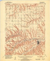
1951 Map of Atwood
USGS Topo · Published 1952About this map
The town of Atwood serves as the central hub of this Rawlins County landscape, situated where the Burlington and Quincy railroad follows the valley of Beaver Creek. The 1950s rural environment is meticulously detailed, showing a high density of country schools and churches that speak to the established homesteading patterns of the era. Of particular note for local historians is the Bohemian Center Sch & St Cyril Ch and several family-centric landmarks like St Johns Ch & Cem and Enterprise Cem. The map documents the water resources of the High Plains, tracing the North Fork Driftwood Creek and Little Beaver Creek as they cut through the terrain. Civil infrastructure of the mid-century is represented by the Municipal Airport and Atwood Lake, while small settlements such as Beardsley and Blakeman are shown as active rail stops during this period of development in the Missouri River Basin.
Find a feature on this map
43 named features on this map. Tap any name to fly to it.
Don’t see what you’re looking for? This feature index may not catch every label — zoom into the map to look around manually.
Map Details
Editions of this 1951 Atwood Map
2 editions found
Other maps of this area

1950 · Mc Donald
USGS Topo · 1:62,500

1951 · Mc Donald
USGS Topo · 1:62,500

1951 · Herndon
USGS Topo · 1:62,500

1951 · Achilles
USGS Topo · 1:62,500

1951 · Chardon
USGS Topo · 1:62,500

1951 · Dewey Ranch
USGS Topo · 1:62,500

1954 · McCook
USGS Topo · 1:250,000

1954 · Goodland
USGS Topo · 1:250,000

1956 · Goodland
USGS Topo · 1:250,000

1957 · McCook
USGS Topo · 1:250,000