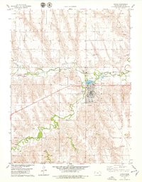
1978 Map of Atwood
USGS Topo · Published 1979About this map
Atwood serves as the focal point of this High Plains landscape, situated at the confluence where Beaver Creek meets Little Beaver Creek. The town's mid-century layout is clearly defined, featuring a concentrated residential grid and essential community landmarks like Atwood Lake Park and a local Golf Course. To the west, the smaller settlement of Blakeman sits along the Burlington Northern railroad corridor, reflecting the importance of rail transport to the regional grain and cattle economy. Cultural sites of interest include the Drive-in Theater just west of the main town and two local burial grounds, Mt Calvary Cem and a second Cemetery further south. The surrounding terrain is marked by the branching drainage of the creeks, with several Sandpits and an Atwood-Rawlins Co Airport indicating the industrial and infrastructure needs of Rawlins County during the late 1970s.
Find a feature on this map
19 named features on this map. Tap any name to fly to it.
Don’t see what you’re looking for? This feature index may not catch every label — zoom into the map to look around manually.
Map Details
Editions of this 1978 Atwood Map
This is the sole edition of this map. No revisions or reprints were ever made.
Other maps of this area

1951 · Herndon
USGS Topo · 1:62,500

1951 · Achilles
USGS Topo · 1:62,500

1951 · Atwood
USGS Topo · 1:62,500

1951 · Chardon
USGS Topo · 1:62,500

1954 · Goodland
USGS Topo · 1:250,000

1956 · Goodland
USGS Topo · 1:250,000

1957 · Goodland
USGS Topo · 1:250,000
1978 · Beardsley
USGS Topo · 1:24,000
1978 · Ludell
USGS Topo · 1:24,000
1978 · Chardon
USGS Topo · 1:24,000