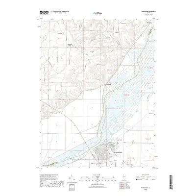
2018 Map of Beardstown
USGS Topo · Published 2018About this map
Beardstown serves as the focal point of this riverfront landscape, situated where the Illinois River meets the Sangamon River. The geography is defined by a vast complex of wetlands and backwaters, including Muscooten Bay, Treadway Lake, and Vetter Slough. This intricate network of sloughs and islands like Grape Island and Sugar Creek Island highlights the dynamic nature of the Illinois River valley. On the higher ground to the west, the terrain rises toward Mansion Hill, where smaller settlements such as Frederick and Pleasant View are located. Genealogists will find numerous family and community burial sites scattered across the uplands, including Gillette Cem, Messerer Cem, and Bellomy Cem. The presence of Bluff Ditch and Coal Creek Ditch illustrates the extensive drainage efforts used to manage the fertile but flood-prone bottomlands surrounding the river junction.
Find a feature on this map
122 named features on this map. Tap any name to fly to it.
Don’t see what you’re looking for? This feature index may not catch every label — zoom into the map to look around manually.
Map Details
Editions of this 2018 Beardstown Map
This is the sole edition of this map. No revisions or reprints were ever made.
Other maps of this area

1923 · Rushville
USGS Topo · 1:62,500

1926 · Beardstown
USGS Topo · 1:62,500

1926 · Rushville
USGS Topo · 1:62,500

1928 · Meredosia
USGS Topo · 1:62,500

1929 · Arenzville
USGS Topo · 1:62,500

1931 · Meredosia
USGS Topo · 1:62,500

1932 · Arenzville
USGS Topo · 1:62,500

1944 · Beardstown
USGS Topo · 1:62,500

1948 · Quincy
USGS Topo · 1:250,000

1956 · Quincy
USGS Topo · 1:250,000