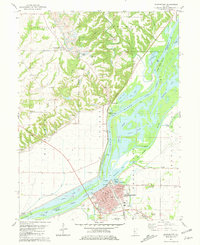
1981 Map of Beardstown
USGS Topo · Published 1981About this map
The Sangamon River and Illinois River converge in this riverine landscape, where the town of Beardstown sits on the southeastern bank. By the early 1980s, the area's infrastructure supported a mix of rail transport and river navigation, evidenced by the Burlington Northern and B & O railroads crossing the terrain near Muscooten Bay. The map reveals a complex system of sloughs and lakes, including Boujan Slough and Treadway Lake, highlighting the seasonal shifts of these major waterways.
Find a feature on this map
55 named features on this map. Tap any name to fly to it.
Don’t see what you’re looking for? This feature index may not catch every label — zoom into the map to look around manually.
Map Details
Editions of this 1981 Beardstown Map
This is the sole edition of this map. No revisions or reprints were ever made.
Other maps of this area

1923 · Rushville
USGS Topo · 1:62,500

1926 · Beardstown
USGS Topo · 1:62,500

1926 · Rushville
USGS Topo · 1:62,500

1928 · Meredosia
USGS Topo · 1:62,500

1929 · Arenzville
USGS Topo · 1:62,500

1931 · Meredosia
USGS Topo · 1:62,500

1932 · Arenzville
USGS Topo · 1:62,500

1944 · Beardstown
USGS Topo · 1:62,500

1948 · Quincy
USGS Topo · 1:250,000

1956 · Quincy
USGS Topo · 1:250,000