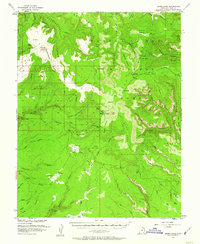
1954 Map of Bears Ears
USGS Topo · Published 1957About this map
Bears Ears towers as the namesake landmark of this 1950s survey, marking a rugged plateau landscape within the Manti-La Sal National Forest. The map documents a period of active land management and early modern access, evidenced by the Kigalia Ranger Sta and a solitary Airstrip situated on the high ridge. This area preserves traces of much older human history, with several Cliff Dwellings and a Natural Arch recorded along the deep incisions of Grand Gulch. The terrain is defined by dramatic transitions from broad, flat mesas like Deer Flat and Harmony Flat to the labyrinthine drainage systems of White Canyon and Mule Canyon. Historic transit is represented by the Mormon Trail, which skirts across Mormon Flat and Hells Half Acre, reflecting the legacy of late 19th-century pioneers who navigated this complex geography.
Find a feature on this map
65 named features on this map. Tap any name to fly to it.
Don’t see what you’re looking for? This feature index may not catch every label — zoom into the map to look around manually.
Map Details
Editions of this 1954 Bears Ears Map
4 editions found

Other maps of this area

1886 · Henry Mountains
USGS Topo · 1:250,000

1886 · Abajo
USGS Topo · 1:250,000

1892 · Abajo
USGS Topo · 1:250,000

1892 · Henry Mountains
USGS Topo · 1:250,000

1893 · Abajo
USGS Topo · 1:250,000

1935 · Elk Ridge
USGS Topo · 1:96,000

1940 · Elk Ridge
USGS Topo · 1:125,000

1952 · Mouth of Dark Canyon
USGS Topo · 1:62,500

1952 · Natural Bridges
USGS Topo · 1:62,500

1954 · Elk Ridge 4 NW
USGS Topo · 1:24,000