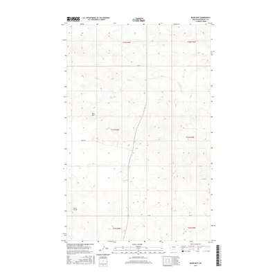
2017 Map of Bears Nest
USGS Topo · Published 2017About this map
Bears Nest rises as a prominent high point in this section of the Wolf Point District, overlooking a landscape defined by intermittent watercourses and technical survey townships. The terrain is marked by the deep cut of Smith Coulee and the drainage patterns of Sage Cr and Assiniboine Cr. Modern rural infrastructure is evidenced by the intersection of Benrud Rd and several numbered access routes including 2042 Rd and RD 2036. Localized water sources like Snell Spring suggest the traditional importance of specific water points in an otherwise arid Montana rangeland, while the flow of Boxelder Cr defines the southern reach of this survey. This record captures the precise topographic character of Roosevelt County during the early 21st century.
Find a feature on this map
15 named features on this map. Tap any name to fly to it.
Don’t see what you’re looking for? This feature index may not catch every label — zoom into the map to look around manually.
Map Details
Editions of this 2017 Bears Nest Map
This is the sole edition of this map. No revisions or reprints were ever made.
Other maps of this area

1910 · Cuskers
USGS Topo · 1:62,500

1915 · Tule Valley
USGS Topo · 1:62,500

1915 · Cuskers
USGS Topo · 1:62,500

1954 · Wolf Point
USGS Topo · 1:250,000

1958 · Wolf Point
USGS Topo · 1:250,000

1973 · Bredette
USGS Topo · 1:24,000

1973 · Nielsen Coulee
USGS Topo · 1:24,000

1973 · Peerless 4 SE
USGS Topo · 1:24,000
1983 · Tule Valley East
USGS Topo · 1:24,000
1983 · Long Creek West
USGS Topo · 1:24,000