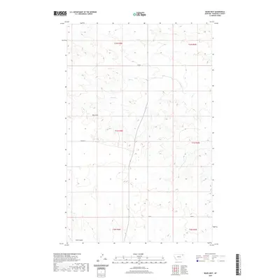
2020 Map of Bears Nest
USGS Topo · Published 2020About this map
Bears Nest rises as a prominent high point in this corner of Roosevelt County, overlooking a landscape defined by seasonal drainages and cattle-country roads. The topography is shaped by the winding courses of Sage Cr in the north and the headwaters of Assiniboine Cr to the south. Historically part of the Fort Peck Indian Reservation, the land shows the sparse infrastructure typical of the northern plains, where local connectivity relies on gravel routes like Benrud Rd and 2042 Rd. Water remains the central feature of the terrain, with Snell Spring providing a critical point of interest among the draws, while Smith Coulee and Boxelder Cr mark the southwestern reaches of the quadrangle. The map details the Public Land Survey System grid, including boundaries for t31n r48e and neighboring townships, reflecting the systematic division of this Montana ranching territory.
Find a feature on this map
15 named features on this map. Tap any name to fly to it.
Don’t see what you’re looking for? This feature index may not catch every label — zoom into the map to look around manually.
Map Details
Editions of this 2020 Bears Nest Map
This is the sole edition of this map. No revisions or reprints were ever made.
Other maps of this area

1910 · Cuskers
USGS Topo · 1:62,500

1915 · Tule Valley
USGS Topo · 1:62,500

1915 · Cuskers
USGS Topo · 1:62,500

1954 · Wolf Point
USGS Topo · 1:250,000

1958 · Wolf Point
USGS Topo · 1:250,000

1973 · Bredette
USGS Topo · 1:24,000

1973 · Nielsen Coulee
USGS Topo · 1:24,000

1973 · Peerless 4 SE
USGS Topo · 1:24,000
1983 · Tule Valley East
USGS Topo · 1:24,000
1983 · Long Creek West
USGS Topo · 1:24,000