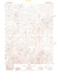
1987 Map of Beatty Mtn
USGS Topo · Published 1987About this map
The Oasis Valley corridor serves as the lifeblood of this arid landscape, where the ephemeral Amargosa River flows through a series of significant riparian features including Hot Springs, Goss Springs, and Revert Springs. This late 1980s data shows a region defined by its geology and extraction history, notably across the northern reaches of Bare Mountain. Mining operations and exploratory prospects are scattered throughout, with specialized sites like the Crowell Mine, Telluride Mine, and Fluorspar workings indicating the specific mineral wealth sought here.
Find a feature on this map
42 named features on this map. Tap any name to fly to it.
Don’t see what you’re looking for? This feature index may not catch every label — zoom into the map to look around manually.
Map Details
Editions of this 1987 Beatty Mtn Map
2 editions found
Other maps of this area

1908 · Kawich
USGS Topo · 1:250,000

1908 · Furnace Creek
USGS Topo · 1:250,000

1910 · Furnace Creek
USGS Topo · 1:250,000

1942 · Tolicha Peak
USGS Topo · 1:125,000

1942 · Bullfrog
USGS Topo · 1:125,000

1948 · Death Valley
USGS Topo · 1:250,000

1954 · Bare Mtn
USGS Topo · 1:62,500

1954 · Bullfrog
USGS Topo · 1:62,500

1954 · Death Valley
USGS Topo · 1:250,000

1954 · Goldfield
USGS Topo · 1:250,000