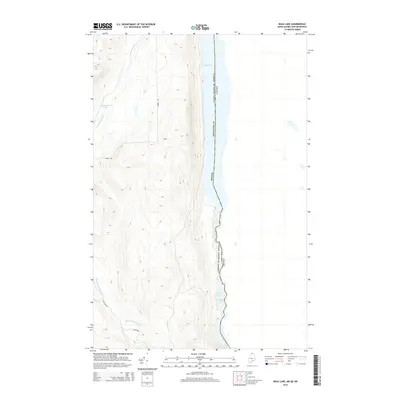
2014 Map of Beau Lake
USGS Topo · Published 2014About this map
The St. Francis River forms a liquid international boundary between Maine and Canada, anchoring this northern forest landscape. This remote stretch of Aroostook County is defined by its significant water bodies, notably Beau Lake in the north and the transition through Cross Lake Rapids into Cross Lake further south. The terrain is marked by steep ridges and drainages like Yankeetuladi Brook, which feeds from Yankeetuladi Pond toward the international line.
Find a feature on this map
12 named features on this map. Tap any name to fly to it.
Don’t see what you’re looking for? This feature index may not catch every label — zoom into the map to look around manually.
Map Details
Editions of this 2014 Beau Lake Map
This is the sole edition of this map. No revisions or reprints were ever made.
Other maps of this area

1930 · Allagash
USGS Topo · 1:48,000

1930 · St Francis
USGS Topo · 1:48,000

1933 · Allagash
USGS Topo · 1:62,500

1933 · St Francis
USGS Topo · 1:62,500

1955 · Beau Lake
USGS Topo · 1:62,500

1962 · Edmundston
USGS Topo · 1:250,000
1975 · St Francis NW
USGS Topo · 1:24,000
1985 · St. Francis
USGS Topo · 1:24,000
1986 · Landry
USGS Topo · 1:24,000

1987 · Beau Lake
USGS Topo · 1:24,000