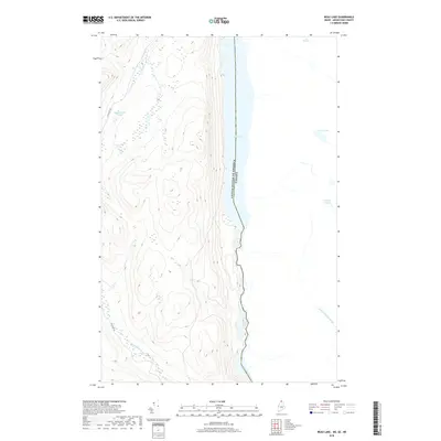
2018 Map of Beau Lake
USGS Topo · Published 2018About this map
Beau Lake and the Saint Francis River define the international boundary at this northern Maine location, where the United States and Canada meet along a water-carved corridor. The terrain is characterized by steep ridges and secluded water bodies, including Yankeetuladi Pond and Lac à Pierre. High elevation contours dominate the landscape west of the river, while smaller tributaries like English Touladi Brook and Yankeetuladi Brook drain the wooded interior. The presence of Cross Lake Rapids along the river highlights the natural flow of this remote drainage system. While Estcourt Rd provides limited terrestrial access on the American side, the map primarily illustrates a landscape shaped by water and the political line separating Maine from Quebec and New Brunswick. This 2018 survey captures the intersection of natural topography and the precisely surveyed international border in one of the most northern reaches of the country.
Find a feature on this map
11 named features on this map. Tap any name to fly to it.
Don’t see what you’re looking for? This feature index may not catch every label — zoom into the map to look around manually.
Map Details
Editions of this 2018 Beau Lake Map
This is the sole edition of this map. No revisions or reprints were ever made.
Other maps of this area

1930 · Allagash
USGS Topo · 1:48,000

1930 · St Francis
USGS Topo · 1:48,000

1933 · Allagash
USGS Topo · 1:62,500

1933 · St Francis
USGS Topo · 1:62,500

1955 · Beau Lake
USGS Topo · 1:62,500

1962 · Edmundston
USGS Topo · 1:250,000
1975 · St Francis NW
USGS Topo · 1:24,000
1985 · St. Francis
USGS Topo · 1:24,000
1986 · Landry
USGS Topo · 1:24,000

1987 · Beau Lake
USGS Topo · 1:24,000