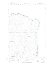
1955 Map of Beau Lake
USGS Topo · Published 1965About this map
The St Francis River forms a jagged international boundary in this northernmost reach of Maine, where the border with Quebec and New Brunswick is defined by water and timberland. This 1955 survey shows the remote border crossing at Estcourt and Estcourt Station, complete with a Customs Office monitoring transit between the United States and Canada. The landscape is dominated by interior water bodies such as Yankeetuladi Pond, Jones Pond, and the expansive Beau Lake, which stretches along the eastern edge of the quadrangle. High ground is marked by Hafey Mountain and Boat Landing Mountain in the south, while a network of woods roads and a Jeep Trail provide the only access through the dense township blocks, including T 19 R 11 and T 20 R 11 & 12. The presence of several rapids, such as Kelly Rapids, underscores the river's character before it meets the larger lake systems.
Find a feature on this map
33 named features on this map. Tap any name to fly to it.
Don’t see what you’re looking for? This feature index may not catch every label — zoom into the map to look around manually.
Map Details
Editions of this 1955 Beau Lake Map
2 editions found
Other maps of this area

1930 · Allagash
USGS Topo · 1:48,000

1930 · St Francis
USGS Topo · 1:48,000

1933 · Allagash
USGS Topo · 1:62,500

1933 · St Francis
USGS Topo · 1:62,500

1955 · Rocky Mountain
USGS Topo · 1:62,500

1955 · Rocky Brook
USGS Topo · 1:62,500

1955 · Beau Lake
USGS Topo · 1:62,500

1962 · Edmundston
USGS Topo · 1:250,000
1975 · St Francis NW
USGS Topo · 1:24,000
1985 · St. Francis
USGS Topo · 1:24,000
Featured Places
- Estcourt Station, Big Twenty Township
- Big Twenty Township, ME
- T19 R12 WELS, ME
- T18 R12 WELS, ME
- T18 R10 WELS, ME