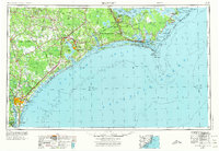
1953 Map of Beaufort
USGS Topo · Published 1974About this map
The coastal landscape of North Carolina's inner and outer banks is dominated by massive military installations and protected wilderness areas in the mid-twentieth century. Major federal footprints are established at the Camp Lejeune US Naval Reservation and MCAS Cherry Point, while the northern reaches of the map show the emerging conservation efforts at Cape Lookout National Seashore and Cedar Island NWR. Inland, the terrain is characterized by extensive wetlands and managed timberlands, including the Croatan National Forest, Hofmann State Forest, and the massive Angola Swamp. Transportation networks of the era rely on the Atlantic Coast Line RR and Seaboard Air Line RR to connect coastal hubs like Morehead City and Beaufort with the agricultural interiors near Kenansville and Burgaw. The map captures the distinct barrier island geography from Bogue Banks up to the remote Portsmouth Island.
Find a feature on this map
298 named features on this map. Tap any name to fly to it.
Don’t see what you’re looking for? This feature index may not catch every label — zoom into the map to look around manually.
Map Details
Editions of this 1953 Beaufort Map
3 editions found

Other maps of this area

1901 · New Bern
USGS Topo · 1:62,500

1903 · New Bern
USGS Topo · 1:62,500

1903 · Trent River
USGS Topo · 1:62,500

1904 · Trent River
USGS Topo · 1:62,500

1942 · Spicer Bay
USGS Topo · 1:62,500

1942 · Topsail
USGS Topo · 1:62,500

1942 · Burgaw
USGS Topo · 1:62,500

1942 · Wilmington
USGS Topo · 1:62,500

1942 · Maysville
USGS Topo · 1:62,500

1942 · Swansboro
USGS Topo · 1:62,500