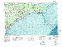
1953 Map of Beaufort
USGS Topo · Published 1983About this map
Wilmington and the surrounding coastal plains define this landscape, where the confluence of the Cape Fear River and the Northeast Cape Fear River historically shaped the region's shipping and transit routes. The interior is characterized by expansive wetlands and woodlands, including the Angola Swamp and the Holly Shelter Swamp, which separate the river-bound settlements from the Atlantic coastline. A heavy military footprint is evident through the sprawling Camp Lejeune US Naval Reservation and Cherry Point US Naval Reservation, contrasting with the preserved natural reaches of the Croatan National Forest. Along the Outer Banks, the Cape Lookout National Seashore protects a string of barrier islands like Core Banks and Shackleford Banks, which stand as buffers against the Atlantic. This survey captures the mid-century infrastructure of the Atlantic Coast Line RR and Seaboard Air Line RR, tracing the rail-dependent growth of towns such as Kenansville, Beulaville, and Burgaw.
Find a feature on this map
156 named features on this map. Tap any name to fly to it.
Don’t see what you’re looking for? This feature index may not catch every label — zoom into the map to look around manually.
Map Details
Editions of this 1953 Beaufort Map
3 editions found

Other maps of this area

1901 · New Bern
USGS Topo · 1:62,500

1903 · New Bern
USGS Topo · 1:62,500

1903 · Trent River
USGS Topo · 1:62,500

1904 · Trent River
USGS Topo · 1:62,500

1942 · Spicer Bay
USGS Topo · 1:62,500

1942 · Topsail
USGS Topo · 1:62,500

1942 · Burgaw
USGS Topo · 1:62,500

1942 · Wilmington
USGS Topo · 1:62,500

1942 · Maysville
USGS Topo · 1:62,500

1942 · Swansboro
USGS Topo · 1:62,500