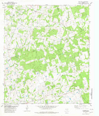
1982 Map of Beaukiss
USGS Topo · Published 1982About this map
The agrarian landscapes of Central Texas intersect at the boundaries of Williamson, Milam, and Lee counties in this 1982 map. Local history is deeply rooted in the small settlements of Beaukiss and Blue, alongside established rural communities like Shiloh and Abbott. The map reveals a high density of local landmarks significant for genealogical research, including the Lawrence Chapel and family-named burial grounds such as Guentzel Cem, Adina Cem, and Burns Cem.
Find a feature on this map
25 named features on this map. Tap any name to fly to it.
Don’t see what you’re looking for? This feature index may not catch every label — zoom into the map to look around manually.
Map Details
Editions of this 1982 Beaukiss Map
This is the sole edition of this map. No revisions or reprints were ever made.
Other maps of this area

1885 · Taylor
USGS Topo · 1:125,000

1885 · Bastrop
USGS Topo · 1:125,000

1887 · Taylor
USGS Topo · 1:125,000

1893 · Bastrop
USGS Topo · 1:125,000

1894 · Taylor
USGS Topo · 1:125,000

1904 · Bastrop
USGS Topo · 1:125,000

1948 · Elgin
USGS Topo · 1:62,500

1948 · Lexington
USGS Topo · 1:62,500

1950 · Lexington
USGS Topo · 1:62,500

1950 · Elgin
USGS Topo · 1:62,500