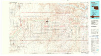
1986 Map of Beaver
USGS Topo · Published 1990About this map
The Cimarron River and the Beaver River define the wide landscape of the Oklahoma Panhandle in this mid-1980s survey. Extensive Oil and Gas Field operations and the Oil Field at Gray indicate the region's industrial foundation, while the Sand Hills north of the river suggest the persistent natural character of the high plains. Small agricultural and ranching centers like Turpin, Forgan, and the county seat at Beaver are connected by a network of roads that occasionally parallel an Old RR Grade, marking the shift in transportation patterns over the decades.
Find a feature on this map
36 named features on this map. Tap any name to fly to it.
Don’t see what you’re looking for? This feature index may not catch every label — zoom into the map to look around manually.
Map Details
Editions of this 1986 Beaver Map
2 editions found
Other maps of this area

1892 · Meade
USGS Topo · 1:125,000

1896 · Ashland
USGS Topo · 1:125,000

1954 · Perryton
USGS Topo · 1:250,000

1955 · Woodward
USGS Topo · 1:250,000

1955 · Pratt
USGS Topo · 1:250,000

1955 · Dodge City
USGS Topo · 1:250,000

1958 · Perryton
USGS Topo · 1:250,000

1958 · Woodward
USGS Topo · 1:250,000

1958 · Dodge City
USGS Topo · 1:250,000

1959 · Pratt
USGS Topo · 1:250,000