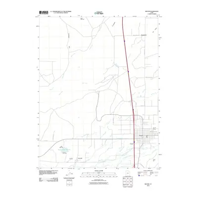
2010 Map of Beaver
USGS Topo · Published 2010About this map
Beaver serves as the central hub in this Southern Utah landscape, where the Beaver River and a network of historic irrigation systems like Carter Ditch and South Field Ditch define the settlement pattern. The map reveals an agrarian structure that spans from the small community of Greenville in the southwest to Manderfield in the northeast, connected by a grid of local roads and the primary north-south transportation corridor. This 2010 survey provides critical detail for genealogists, locating the Mountain View Cemetery, Beaver City Cemetery, and Greenville Cemetery. The area's dependence on managed water is evident in features such as the Robinson-Tanner Reservoir and the Beaver-Fish Hatchery, while the surrounding terrain rises toward landmarks like Black Mountain and The Hogback.
Find a feature on this map
40 named features on this map. Tap any name to fly to it.
Don’t see what you’re looking for? This feature index may not catch every label — zoom into the map to look around manually.
Map Details
Editions of this 2010 Beaver Map
This is the sole edition of this map. No revisions or reprints were ever made.
Other maps of this area

1885 · Beaver
USGS Topo · 1:250,000

1953 · Richfield
USGS Topo · 1:250,000

1954 · Beaver SE
USGS Topo · 1:24,000

1954 · Beaver NE
USGS Topo · 1:24,000

1958 · Richfield
USGS Topo · 1:250,000

1958 · Minersville
USGS Topo · 1:62,500

1958 · Beaver
USGS Topo · 1:62,500

1958 · Adamsville
USGS Topo · 1:62,500
1971 · Kane Canyon
USGS Topo · 1:24,000
1971 · Greenville Bench
USGS Topo · 1:24,000