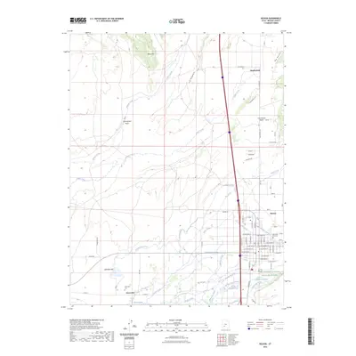
2023 Map of Beaver
USGS Topo · Published 2023About this map
Beaver serves as the central hub of this agricultural and desert landscape, characterized by a complex network of irrigation systems and water management. The area's reliance on the Beaver River is evident through numerous diversions such as City Ditch, Patterson Ditch, and Northwest Ditch, which support the outlying settlements of Manderfield and Greenville. The terrain transitions from the high peaks of Black Mtn and The Hogback in the north to the more level expanses of Last Chance Bench. Local history and genealogy are anchored by the Mountain View Cem in Beaver and the Greenville Cem further west. To the south, a portion of the Fish Springs National Wildlife Refuge borders the varied wetland features of Bullberry Slough and Greenwood Slough, illustrating the delicate balance of water use in this arid region.
Find a feature on this map
78 named features on this map. Tap any name to fly to it.
Don’t see what you’re looking for? This feature index may not catch every label — zoom into the map to look around manually.
Map Details
Editions of this 2023 Beaver Map
This is the sole edition of this map. No revisions or reprints were ever made.
Other maps of this area

1885 · Beaver
USGS Topo · 1:250,000

1953 · Richfield
USGS Topo · 1:250,000

1954 · Beaver SE
USGS Topo · 1:24,000

1954 · Beaver NE
USGS Topo · 1:24,000

1958 · Richfield
USGS Topo · 1:250,000

1958 · Minersville
USGS Topo · 1:62,500

1958 · Beaver
USGS Topo · 1:62,500

1958 · Adamsville
USGS Topo · 1:62,500
1971 · Kane Canyon
USGS Topo · 1:24,000
1971 · Greenville Bench
USGS Topo · 1:24,000