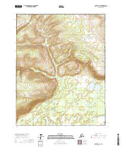
2017 Map of Beaver C-1 SE
USGS Topo · Published 2017About this map
Yukon Flats dominates the landscape of this interior Alaska region, where the terrain transitions from the broad alluvial plain toward the rising elevations of the northern uplands. In this 2017 study, the drainage of Twentyfour Mile Cr is visible in the northwestern corner, cutting through the township boundaries of T21N R2E and T21N R3E. The map detail reflects a largely undeveloped wilderness within the Yukon-Koyukuk Census Area, characterized by intricate contour lines and scattered wetlands. The absence of permanent road infrastructure or settlements highlights the isolation of this portion of the flats, a contrast to more developed river corridors elsewhere in the state. Researchers of Alaskana will find the precise Public Land Survey System grids, maintained by the BLM, useful for locating specific geographic coordinates in this remote quadrant.
Find a feature on this map
8 named features on this map. Tap any name to fly to it.
Don’t see what you’re looking for? This feature index may not catch every label — zoom into the map to look around manually.
Map Details
Editions of this 2017 Beaver C-1 SE Map
This is the sole edition of this map. No revisions or reprints were ever made.
Other maps of this area

1951 · Fort Yukon
USGS Topo · 1:250,000

1951 · Beaver
USGS Topo · 1:250,000

1956 · Fort Yukon B-6
USGS Topo · 1:63,360

1956 · Beaver
USGS Topo · 1:250,000

1956 · Beaver B-1
USGS Topo · 1:63,360

1956 · Fort Yukon
USGS Topo · 1:250,000
1956 · Fort Yukon C-6
USGS Topo · 1:63,360

1964 · Beaver
USGS Topo · 1:250,000
1990 · Beaver C-1
USGS Topo · 1:63,360
2017 · Beaver C-1 NE
USGS Topo · 1:25,000