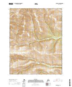
2017 Map of Beaver C-6 NE
USGS Topo · Published 2017About this map
The Hodzana River flows through the southeastern portion of this landscape in the Yukon-Koyukuk Census Area. This 2017 survey shows a region defined primarily by its high-elevation topography and public land subdivisions, including portions of T22n R10w, T22n R9w, T21n R10w, and T21n R9w. The map provides a detailed view of the natural drainages and mountain ridges that characterize this part of interior Alaska, where the river serves as the primary named geographical feature. Without roads or settlements, the topography itself is the primary record of the land, detailing the intricate network of slopes and valleys that feed into the river system.
Find a feature on this map
5 named features on this map. Tap any name to fly to it.
Don’t see what you’re looking for? This feature index may not catch every label — zoom into the map to look around manually.
Map Details
Editions of this 2017 Beaver C-6 NE Map
This is the sole edition of this map. No revisions or reprints were ever made.
Other maps of this area

1951 · Beaver
USGS Topo · 1:250,000

1956 · Beaver
USGS Topo · 1:250,000

1964 · Beaver
USGS Topo · 1:250,000
1970 · Beaver D-5
USGS Topo · 1:63,360
1970 · Beaver C-6
USGS Topo · 1:63,360
1970 · Beaver C-5
USGS Topo · 1:63,360
1970 · Beaver D-6
USGS Topo · 1:63,360
2017 · Beaver D-6 SW
USGS Topo · 1:25,000
2017 · Beaver D-6 SE
USGS Topo · 1:25,000
2017 · Beaver C-6 NW
USGS Topo · 1:25,000