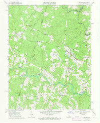
1969 Map of Beaverdam
USGS Topo · Published 1971About this map
The Chesapeake and Ohio railroad corridor anchors this survey, connecting rural communities like Bumpass and Beaverdam across the Virginia Piedmont. The landscape is defined by the winding course of the Little River and the North Anna River, which forms the boundary between Spotsylvania and Caroline counties. Settled agricultural patterns are evident in the numerous small family burial grounds and country churches, including St Thomas Ch and Rouzie Chapel. Local industry and rural infrastructure are represented by Fleming Millpond and Fulcher Millpond, alongside small-scale commerce at Terrell Store. This era shows a transition from traditional land use to early modern development, noted by the presence of a Landing Strip near the Louisa and Hanover county line, while evocative place names like Old Bandana persist in the local geography.
Find a feature on this map
37 named features on this map. Tap any name to fly to it.
Don’t see what you’re looking for? This feature index may not catch every label — zoom into the map to look around manually.
Map Details
Editions of this 1969 Beaverdam Map
Other maps of this area

1887 · Spottsylvania
USGS Topo · 1:125,000

1890 · Goochland
USGS Topo · 1:125,000

1892 · Spottsylvania
USGS Topo · 1:125,000

1892 · Goochland
USGS Topo · 1:125,000

1942 · Ladysmith
USGS Topo · 1:31,680

1942 · Partlow
USGS Topo · 1:31,680

1942 · Contrary Creek
USGS Topo · 1:31,680

1942 · Buckner
USGS Topo · 1:24,000

1942 · Beaverdam
USGS Topo · 1:24,000

1943 · Mabelton
USGS Topo · 1:31,680