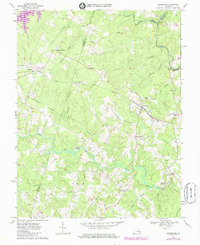
1969 Map of Beaverdam
USGS Topo · Published 1985About this map
The Chesapeake and Ohio railroad corridor serves as the central spine of this rural landscape, connecting small crossroads and farming hubs like Beaverdam and Bumpass. The terrain is defined by the meandering North Anna River and the Little River, which weave through heavily wooded creek basins including Hollowing Creek and Roan Horse Creek. A significant landscape change is visible at the edge of the sheet where Lake Anna begins to take shape, marking the transition from riverine valley to reservoir. Evidence of long-standing community life is found at Beaverdam Sch, Rouzie Chapel, and St Thomas Ch, alongside numerous small family cemeteries. Local industry and water management are represented by Fleming Millpond and Fulcher Millpond, while the presence of a Landing Strip near Greenes Corner reflects the modernization of transportation alongside the older rail and river networks.
Find a feature on this map
43 named features on this map. Tap any name to fly to it.
Don’t see what you’re looking for? This feature index may not catch every label — zoom into the map to look around manually.
Map Details
Editions of this 1969 Beaverdam Map
Other maps of this area

1887 · Spottsylvania
USGS Topo · 1:125,000

1890 · Goochland
USGS Topo · 1:125,000

1892 · Spottsylvania
USGS Topo · 1:125,000

1892 · Goochland
USGS Topo · 1:125,000

1942 · Ladysmith
USGS Topo · 1:31,680

1942 · Partlow
USGS Topo · 1:31,680

1942 · Contrary Creek
USGS Topo · 1:31,680

1942 · Buckner
USGS Topo · 1:24,000

1942 · Beaverdam
USGS Topo · 1:24,000

1943 · Mabelton
USGS Topo · 1:31,680