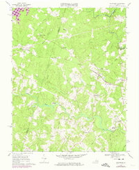
1969 Map of Beaverdam
USGS Topo · Published 1974About this map
The Chesapeake and Ohio railroad cuts a prominent path through this 1960s landscape, anchoring the settlement of Beaverdam and connecting it to smaller communities like Tylers and Teman. This rural stretch of the Virginia Piedmont is defined by its complex drainage network, where the North Anna River forms the border between Spotsylvania, Caroline, and Hanover counties. Recent changes are evident near the northwestern corner, where the rising waters of Lake Anna began to alter the terrain of the Rock Creek valley.
Find a feature on this map
40 named features on this map. Tap any name to fly to it.
Don’t see what you’re looking for? This feature index may not catch every label — zoom into the map to look around manually.
Map Details
Editions of this 1969 Beaverdam Map
Other maps of this area

1887 · Spottsylvania
USGS Topo · 1:125,000

1890 · Goochland
USGS Topo · 1:125,000

1892 · Spottsylvania
USGS Topo · 1:125,000

1892 · Goochland
USGS Topo · 1:125,000

1942 · Ladysmith
USGS Topo · 1:31,680

1942 · Partlow
USGS Topo · 1:31,680

1942 · Contrary Creek
USGS Topo · 1:31,680

1942 · Buckner
USGS Topo · 1:24,000

1942 · Beaverdam
USGS Topo · 1:24,000

1943 · Mabelton
USGS Topo · 1:31,680