
1968 Map of Bedford Hill
USGS Topo · Published 1971About this map
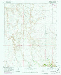
Revuelto Creek and San Jon Creek wind through the high plains of Quay County in this 1960s survey. The landscape is defined by the cattle-ranching and water infrastructure essential to this arid environment, evidenced by labels for the Wooten Ranch (Headquarters) and the Wallace Ranch. Water management for livestock is particularly prominent, with named sites such as Joe Keyes Tank, Bedford Spring, and the Mesa Windmill dotting the terrain. In the northern reaches, the Chicago Rock Island and Pacific RR cuts a straight line through the territory, highlighting the importance of rail transport for moving goods across the eastern New Mexico mesas. The eponymous Bedford Hill rises as a landmark above the creek drainage, overlooking a region where small-scale extraction is noted by the presence of localized Gravel Pits.
Find a feature on this map
14 named features on this map. Tap any name to fly to it.
Don’t see what you’re looking for? This feature index may not catch every label — zoom into the map to look around manually.
Map Details
Editions of this 1968 Bedford Hill Map
2 editions found
Other maps of this area

1930 · Tucumcari
USGS Topo · 1:125,000

1954 · Tucumcari
USGS Topo · 1:250,000

1954 · Clovis
USGS Topo · 1:250,000

1958 · Clovis
USGS Topo · 1:250,000

1958 · Tucumcari
USGS Topo · 1:250,000

1968 · Porter
USGS Topo · 1:24,000

1968 · San Jon
USGS Topo · 1:24,000

1968 · San Jon NW
USGS Topo · 1:24,000

1968 · Lesbia
USGS Topo · 1:24,000
1968 · Tucumcari SE
USGS Topo · 1:24,000