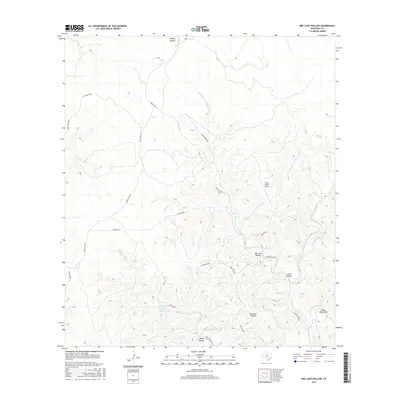
2016 Map of Bee Cave Hollow
USGS Topo · Published 2016About this map
Short-Prong W Frio River carves a complex drainage network through this portion of Real County, defining a landscape dominated by deep canyons and significant karst features. The presence of numerous named water sources, including Prade Springs, Bee Cave Spring, Big Springs, and Chittim Springs, suggests a region where groundwater access was critical for ranching and early habitation. The distribution of family-named landmarks like Ranger Hollow, Anvil Hollow, and Buckalue Hollow indicates a long history of local land usage. Transportation is anchored by Ranch Rd 336 and the Prade Ranch Airport, which facilitates access to this remote terrain. The map also identifies geological and hydrologic points of interest such as Yellow Bluff Draw and Miller Springs, providing a detailed look at the rural character of the Texas Hill Country in the early 21st century.
Find a feature on this map
32 named features on this map. Tap any name to fly to it.
Don’t see what you’re looking for? This feature index may not catch every label — zoom into the map to look around manually.
Map Details
Editions of this 2016 Bee Cave Hollow Map
This is the sole edition of this map. No revisions or reprints were ever made.
Other maps of this area

1954 · Llano
USGS Topo · 1:250,000

1954 · San Antonio
USGS Topo · 1:250,000

1955 · Llano
USGS Topo · 1:250,000

1956 · Llano
USGS Topo · 1:250,000

1957 · San Antonio
USGS Topo · 1:250,000

1963 · Garven Store
USGS Topo · 1:24,000

1964 · Hillcrest Ranch
USGS Topo · 1:24,000

1964 · Circle Bluff
USGS Topo · 1:24,000
1971 · Earwood Creek
USGS Topo · 1:24,000
1971 · Owl Hollow
USGS Topo · 1:24,000