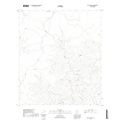
2019 Map of Bee Cave Hollow
USGS Topo · Published 2019About this map
Short Prong W Frio River winds through the limestone-carved landscape of Real County, defining a topography of narrow draws and steep ridges. This ranching territory in the Texas Hill Country is marked by a network of seasonal water sources and springs, including Bee Cave Spring, Chittim Springs, and Big Springs. The drainage patterns are clearly visible through deeply incised features like Anvil Hollow, Buckalue Hollow, and Ranger Hollow, which funnel towards the river system. Transportation through this remote terrain is centered on Ranch Rd 336, which follows the high ground between the river's loops. The presence of the Prade Ranch Airport and Prade Ranch Rd indicates the localized development associated with large private holdings and aviation access in the Edwards Plateau region.
Find a feature on this map
30 named features on this map. Tap any name to fly to it.
Don’t see what you’re looking for? This feature index may not catch every label — zoom into the map to look around manually.
Map Details
Editions of this 2019 Bee Cave Hollow Map
This is the sole edition of this map. No revisions or reprints were ever made.
Other maps of this area

1954 · Llano
USGS Topo · 1:250,000

1954 · San Antonio
USGS Topo · 1:250,000

1955 · Llano
USGS Topo · 1:250,000

1956 · Llano
USGS Topo · 1:250,000

1957 · San Antonio
USGS Topo · 1:250,000

1963 · Garven Store
USGS Topo · 1:24,000

1964 · Hillcrest Ranch
USGS Topo · 1:24,000

1964 · Circle Bluff
USGS Topo · 1:24,000
1971 · Earwood Creek
USGS Topo · 1:24,000
1971 · Owl Hollow
USGS Topo · 1:24,000