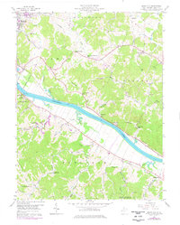
1957 Map of Beech Hill
USGS Topo · Published 1976About this map
The Kanawha River serves as the central artery for this industrial and agricultural landscape in Mason County, where the Conrail line and a network of named creek valleys defined the settlement patterns of the mid-20th century. While the city limits of Point Pleasant occupy the northwest corner, the map primarily illustrates the rural life and development of the surrounding districts of Lewis, Cooper, Clendenin, and Arbuckle. Small social centers are anchored by local institutions such as the Morning Star Ch and the Franklin D Roosevelt Sch. The landscape is a mix of small-scale industry, including several unnamed Mines and a Coast Guard Sta, alongside preserved spaces like the Chief Cornstalk Hunting Ground. Genealogists will find a wealth of family history in the many small burial grounds and churches scattered through the hills, such as the Hoschar Cem and Hickory Chapel.
Find a feature on this map
61 named features on this map. Tap any name to fly to it.
Don’t see what you’re looking for? This feature index may not catch every label — zoom into the map to look around manually.
Map Details
Editions of this 1957 Beech Hill Map
2 editions found

Other maps of this area

1906 · Glenwood
USGS Topo · 1:62,500

1906 · Winfield
USGS Topo · 1:62,500

1908 · Glenwood
USGS Topo · 1:62,500

1908 · Winfield
USGS Topo · 1:62,500

1908 · Ravenswood
USGS Topo · 1:62,500

1908 · Point Pleasant
USGS Topo · 1:62,500

1926 · Ravenswood
USGS Topo · 1:62,500

1926 · Point Pleasant
USGS Topo · 1:62,500

1928 · Ravenswood
USGS Topo · 1:62,500

1929 · Point Pleasant
USGS Topo · 1:62,500