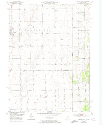
1953 Map of Beecher East
USGS Topo · Published 1974About this map
The village of Beecher and the surrounding agricultural landscape of Washington and Yellowhead townships are captured here during a period of transition in the mid-20th century. This area along the Illinois Indiana border shows a dense network of rural infrastructure, including traditional sites of worship and burial like St Johns Ch and St Lukes Cem. The landscape is defined by the drainage patterns of Trim Creek, Pike Creek, and West Creek, which serve as the primary topographical features of this flat Midwestern prairie.
Find a feature on this map
26 named features on this map. Tap any name to fly to it.
Don’t see what you’re looking for? This feature index may not catch every label — zoom into the map to look around manually.
Map Details
Editions of this 1953 Beecher East Map
3 editions found
Other maps of this area

1922 · Momence
USGS Topo · 1:62,500

1924 · Momence
USGS Topo · 1:62,500

1929 · Dyer
USGS Topo · 1:24,000

1930 · Dyer
USGS Topo · 1:24,000

1930 · Steger
USGS Topo · 1:24,000

1949 · Crete
USGS Topo · 1:62,500

1953 · St. John
USGS Topo · 1:24,000
1953 · Steger
USGS Topo · 1:24,000

1953 · Beecher West
USGS Topo · 1:24,000

1953 · Beecher East
USGS Topo · 1:24,000