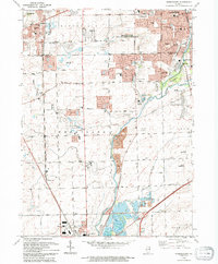
1993 Map of Normantown
USGS Topo · Published 1994About this map
The Du Page River valley and its surrounding townships define this landscape during a period of rapid suburban transition in the 1990s. The convergence of Naperville, Plainfield, and Bolingbrook creates a dense network of residential subdivisions and golf courses, such as White Eagle Golf Course, while preserving pockets of the area's agricultural past. Long-standing local landmarks like the Vermont Cem and Wheatland Cem remain as quiet reminders of earlier settlement patterns amidst the expanding grid of the Plainfield-Naperville Road.
Find a feature on this map
66 named features on this map. Tap any name to fly to it.
Don’t see what you’re looking for? This feature index may not catch every label — zoom into the map to look around manually.
Map Details
Editions of this 1993 Normantown Map
This is the sole edition of this map. No revisions or reprints were ever made.
Other maps of this area

1892 · Joliet
USGS Topo · 1:62,500

1908 · Wheaton
USGS Topo · 1:62,500

1923 · Joliet
USGS Topo · 1:62,500

1925 · Yorkville
USGS Topo · 1:62,500

1932 · Geneva
USGS Topo · 1:62,500

1948 · Wheaton
USGS Topo · 1:62,500

1948 · Geneva
USGS Topo · 1:62,500

1950 · Aurora North
USGS Topo · 1:24,000

1953 · Naperville
USGS Topo · 1:24,000

1953 · Yorkville SE
USGS Topo · 1:24,000