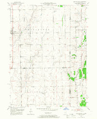
1953 Map of Beecher East
USGS Topo · Published 1967About this map
The Chicago and Eastern Illinois railroad runs north-south through Beecher, anchoring a landscape of rural farmsteads and township boundaries in the mid-1950s. This survey captures the borderlands of Will and Kankakee Counties in Illinois alongside Lake County, Indiana, where the terrain is defined by the drainage of Trim Creek, Pike Creek, and West Creek. Smaller settlements like Brunswick and Klaasville reflect the area’s agricultural heritage, supported by local institutions such as Deeke Sch and St Johns Ch. The presence of several family or community burial grounds, including Fuller Cem and Brunswick Cem, alongside St Lukes Cem near the Beecher townsite, offers significant detail for genealogical research. The map also illustrates the path of the Chicago Milwaukee St Paul and Pacific line as it cuts through the southern townships of Washington and Yellowhead.
Find a feature on this map
22 named features on this map. Tap any name to fly to it.
Don’t see what you’re looking for? This feature index may not catch every label — zoom into the map to look around manually.
Map Details
Editions of this 1953 Beecher East Map
3 editions found
Other maps of this area

1922 · Momence
USGS Topo · 1:62,500

1924 · Momence
USGS Topo · 1:62,500

1929 · Dyer
USGS Topo · 1:24,000

1930 · Dyer
USGS Topo · 1:24,000

1930 · Steger
USGS Topo · 1:24,000

1949 · Crete
USGS Topo · 1:62,500

1953 · St. John
USGS Topo · 1:24,000
1953 · Steger
USGS Topo · 1:24,000

1953 · Beecher West
USGS Topo · 1:24,000

1953 · Beecher East
USGS Topo · 1:24,000