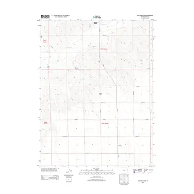
2013 Map of Beecher Island
USGS Topo · Published 2013About this map
Arikaree River and Sand Cr cut through the high plains of eastern Yuma County, marking a landscape defined by ranching and frontier history. This 2013 survey documents the site of Beecher Island, located where the riverbed broadens. The area's topography is characterized by features like Peate Hill and Lansing Valley, which suggest the sparse but enduring settlement of this cattle country. The grid of county roads, including Co Road 15 and Co Road LL, provides access to local landmarks such as the M K Ranch and the Lansing Valley Cem. Agricultural water management is evident at Duck Reservoir and Whombles Meadow, highlighting the importance of every drainage in this semi-arid region. For those researching local lineages or the 1868 conflict associated with the island, the map offers precise placement of these rural features.
Find a feature on this map
29 named features on this map. Tap any name to fly to it.
Don’t see what you’re looking for? This feature index may not catch every label — zoom into the map to look around manually.
Map Details
Editions of this 2013 Beecher Island Map
This is the sole edition of this map. No revisions or reprints were ever made.
Other maps of this area

1950 · Bonny Reservoir
USGS Topo · 1:62,500

1954 · Limon
USGS Topo · 1:250,000

1957 · Limon
USGS Topo · 1:250,000

1958 · Limon
USGS Topo · 1:250,000

1963 · Vernon
USGS Topo · 1:24,000

1963 · Beecher Island
USGS Topo · 1:24,000
1963 · Armel
USGS Topo · 1:24,000

1963 · Beecher Island NW
USGS Topo · 1:24,000
1963 · Willow Creek Ranch
USGS Topo · 1:24,000

1963 · Wildcat Canyon
USGS Topo · 1:24,000