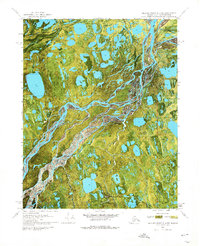
1970 Map of Beechey Point A-2 NW
USGS Topo · Published 1974About this map
The braided channels of the Sagavanirktok River dominate this 1970 orthophotomap of Alaska’s North Slope, showing the complex aquatic landscape just as industrial exploration began to reshape the region. The imagery reveals a mosaic of thermokarst lakes and tundra wetlands, providing a precise visual record of the land surface before extensive development. Early energy infrastructure is evidenced by the Delta State No 1 and Kadler State No 1 sites, which represent the initial footprint of state-managed mineral interests in the Arctic. Aviation and seasonal transport were essential for accessing these remote locations, documented here by the Coastal Landing Strip, the Kadler Landing Strip, and a designated Winter Trail. This survey captures a specific moment in the evolution of the Alaskan frontier where traditional wilderness and modern extraction began to converge.
Find a feature on this map
6 named features on this map. Tap any name to fly to it.
Don’t see what you’re looking for? This feature index may not catch every label — zoom into the map to look around manually.
Map Details
Editions of this 1970 Beechey Point A-2 NW Map
2 editions found
Other maps of this area

1951 · Beechey Point
USGS Topo · 1:250,000

1955 · Beechey Point
USGS Topo · 1:250,000

1955 · Beechey Point B-2
USGS Topo · 1:63,360

1955 · Beechey Point A-2
USGS Topo · 1:63,360

1955 · Beechey Point A-3
USGS Topo · 1:63,360

1955 · Beechey Point B-3
USGS Topo · 1:63,360

1960 · Beechey Point
USGS Topo · 1:250,000

1962 · Beechey Point B-2
USGS Topo · 1:50,000
1962 · Beechey Point A-2
USGS Topo · 1:50,000

1964 · Beechey Point
USGS Topo · 1:250,000